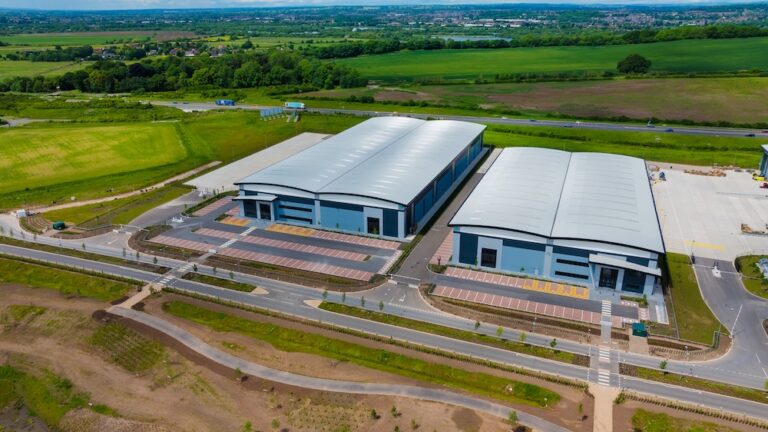
Simply, this is a satellite image created from a UAV (Drone)
Orthomosaic is a mouthful, short versions we use include, topo/otho/satellite map
Depending on the size of the site, combining hundreds, sometimes thousands of images into one single image. This single images is corrected for any anomalies and exported as a single map, usually as a GEO Tiff, but can be exported as a point cloud, PDF Map, Jpeg and many more.
A construction orthomosaic map is an incredible tool for surveyors and those working directly in highways projects. This type of map is generated using aerial imagery captured by a drone or other aerial vehicle, and is used to provide a detailed and accurate view of a construction site and its surroundings.
For surveyors, construction orthomosaic maps can be used to gather data on topography, land features, and existing infrastructure. The map can be used to measure distances, calculate areas, and identify potential obstacles or hazards. The final high-resolution image can provide a detailed view of the site, allowing surveyors to plan their work more effectively saving time and money.
In highway projects, construction orthomosaic maps can be used to monitor the progress of construction and identify potential issues. The map can be used to track changes to the site over time, usually monthly, such as the addition of new roads or structures, and can be used to identify areas that may be at risk of erosion, settling, or other types of damage.
One of the key advantages of using construction orthomosaic maps in surveying and highway projects is their high level of accuracy. The maps are georeferenced, meaning that they are aligned with real-world coordinates on the ground, and can be used for precise measurements and analysis from anywhere in the world. This accuracy helps surveyors and highway engineers make more informed decisions, ultimately leading to better outcomes for the project.
In addition to providing a detailed view of the construction site, orthomosaic maps can also be used to generate 3D models and topographic maps of the site. This can be particularly useful for surveyors, as it can help them to understand the terrain and identify potential challenges that may impact their work.
In summery, construction ortho maps are a valuable tool for surveyors and those involved in highway projects. They provide a high-resolution, accurate view of the construction site and its surroundings, which can be used to plan work more effectively, monitor progress, and identify potential issues. By using this technology, surveyors and highway engineers can work more efficiently and make more informed decisions, ultimately leading to better outcomes for their projects.
Need help on your project? Get in touch.

Accuracy is usually down to few centimetres using the latest satellite RTK technology.
Perfect uses include
- Initial topography mapping
- Monthly progress reviews
- Site planning
- Comparing start and end models
- Aiding with planning requests
Our clients use these maps from us for their major meetings with the main contractors or council and we feel we’re just touching the tip of the iceberg on drone technology and what is possible.
Typically we will complete maps around 50 acres / 20 hectares / 2million SQFT, in a day.
As registered and authorised drone operators almost any site location can be mapped, to get started contact us here.